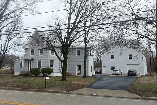
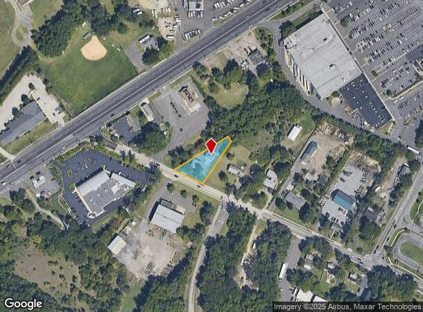
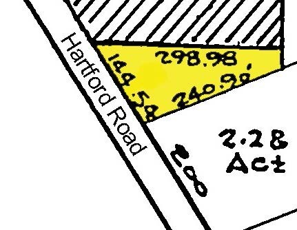
Property Record
15 Hartford Rd, Delran, NJ 08075
NEARBY LISTINGS FOR SALE OR LEASE
Property Detail
15 Hartford Rd
10-00120-07-00028-01
Burlington
Commercialnec
New Jersey
X
28.1
34005C0114F
0.79 AC
2024
Burlington
2025
Philadelphia
700602
Philadelphia-Camden-Wilmington, PA-NJ-DE-MD
1,317 SF
DEMOGRAPHICS near 15 Hartford Rd
1 Mile
3 Mile
5 Mile
2024 Total Population
7,424
58,498
229,639
2029 Population
7,544
59,476
229,522
Pop Growth 2024-2029
+ 1.62%
+ 1.67%
(0.05%)
Average Age
41
42
41
2024 Total Households
2,590
22,138
88,160
HH Growth 2024-2029
+ 1.62%
+ 1.39%
(0.20%)
Median Household Inc
$103,155
$93,203
$86,853
Avg Household Size
2.80
2.60
2.50
2024 Avg HH Vehicles
2.00
2.00
2.00
Median Home Value
$263,065
$266,011
$251,635
Median Year Built
1968
1969
1965
Nearby Places
Map Layers
Map Styles
 Street
 Aerial
- Restaurants
- Banks
- Shops
- Fitness
- Groceries
PUBLIC TRANSPORTATION
COMMUTER RAIL
Tacony (R7 - Southeastern Pennsylvania Transportation Authority Regional Rail (SEPTA Regional Rail))
DRIVE
WALK
Distance
Tacony (R7 - Southeastern Pennsylvania Transportation Authority Regional Rail (SEPTA Regional Rail))
17 min
8.3 mi
Holmesburg Junction (R7 - Southeastern Pennsylvania Transportation Authority Regional Rail (SEPTA Regional Rail))
DRIVE
WALK
Distance
Holmesburg Junction (R7 - Southeastern Pennsylvania Transportation Authority Regional Rail (SEPTA Regional Rail))
19 min
9.5 mi
AIRPORT
Philadelphia International
DRIVE
WALK
Distance
Philadelphia International
39 min
23.3 mi
Trenton Mercer
DRIVE
WALK
Distance
Trenton Mercer
40 min
24.3 mi
Freight Ports
Port of Philadelphia
DRIVE
WALK
Distance
Port of Philadelphia
20 min
10.9 mi
Nearby Properties
Address
Land Use
TOTAL SIZE
Lot Size
Zoning
Address
Land Use
TOTAL SIZE
Lot Size
Zoning
72.46 AC
Address
Land Use
TOTAL SIZE
Lot Size
Zoning
2,183 SF
61.10 AC
Address
Land Use
TOTAL SIZE
Lot Size
Zoning
95.79 AC
Address
Land Use
TOTAL SIZE
Lot Size
Zoning
16.69 AC
Address
Land Use
TOTAL SIZE
Lot Size
Zoning
5.70 AC
R2
Address
Land Use
TOTAL SIZE
Lot Size
Zoning
15.02 AC
Address
Land Use
TOTAL SIZE
Lot Size
Zoning
22.49 AC
Address
Land Use
TOTAL SIZE
Lot Size
Zoning
27.33 AC
Address
Land Use
TOTAL SIZE
Lot Size
Zoning
82.32 AC
Address
Land Use
TOTAL SIZE
Lot Size
Zoning
19 AC
Address
Land Use
TOTAL SIZE
Lot Size
Zoning
Address
Land Use
TOTAL SIZE
Lot Size
Zoning
79.78 AC
Address
Land Use
TOTAL SIZE
Lot Size
Zoning
Address
Land Use
TOTAL SIZE
Lot Size
Zoning
24.56 AC
Address
Land Use
TOTAL SIZE
Lot Size
Zoning
205,472 SF
8.40 AC
RM2
Address
Land Use
TOTAL SIZE
Lot Size
Zoning
20.30 AC
Address
Land Use
TOTAL SIZE
Lot Size
Zoning
19.97 AC
Address
Land Use
TOTAL SIZE
Lot Size
Zoning
39.58 AC
Address
Land Use
TOTAL SIZE
Lot Size
Zoning
152,835 SF
4.46 AC
RM2
Address
Land Use
TOTAL SIZE
Lot Size
Zoning
3.44 AC
I-2
Address
Land Use
TOTAL SIZE
Lot Size
Zoning
Address
Land Use
TOTAL SIZE
Lot Size
Zoning
Address
Land Use
TOTAL SIZE
Lot Size
Zoning
28.64 AC
Address
Land Use
TOTAL SIZE
Lot Size
Zoning
130,000 SF
12.50 AC
RM2
Address
Land Use
TOTAL SIZE
Lot Size
Zoning
7.97 AC
Address
Land Use
TOTAL SIZE
Lot Size
Zoning
28.32 AC
CD
Address
Land Use
TOTAL SIZE
Lot Size
Zoning
218,670 SF
16.06 AC
I-2
Address
Land Use
TOTAL SIZE
Lot Size
Zoning
59.32 AC
Address
Land Use
TOTAL SIZE
Lot Size
Zoning
53,009 SF
5.44 AC
RM2
Address
Land Use
TOTAL SIZE
Lot Size
Zoning
25.70 AC
The World's #1 Commercial Real Estate Marketplace
Connect with us
© 2025 CoStar Group
The information above has been obtained from sources believed reliable. While we do not doubt its accuracy we have not verified it and make no guarantee, warranty or representation about it. It is your responsibility to independently confirm its accuracy and completeness. Any projections, opinions, assumptions, or estimates used are for example only and do not represent the current or future performance of the property. The value of this transaction to you depends on tax and other factors which should be evaluated by your tax, financial, and legal advisors. You and your advisors should conduct a careful, independent investigation of the property to determine to your satisfaction the suitability of the property for your needs.